


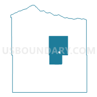
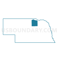
Precinct 8, Holt County, Nebraska
About
Outline

Summary
| Unique Area Identifier | 613266 |
| Name | Precinct 8 |
| County | Holt County |
| State | Nebraska |
| Area (square miles) | 189.35 |
| Land Area (square miles) | 189.26 |
| Water Area (square miles) | 0.09 |
| % of Land Area | 99.95 |
| % of Water Area | 0.05 |
| Latitude of the Internal Point | 42.48680310 |
| Longtitude of the Internal Point | -98.66749830 |
Maps

Graphs
Select a template below for downloading or customizing gragh for Precinct 8, Holt County, Nebraska


Neighbors
Neighoring Voting District (by Name) Neighboring Voting District on the Map
- Voting District 10P, Holt County, NE
- Voting District 11P, Holt County, NE
- Voting District 12P, Holt County, NE
- Voting District 13P, Holt County, NE
- Precinct 1, Holt County, NE
- Precinct 2, Holt County, NE
- Precinct 3, Holt County, NE
- Precinct 4, Holt County, NE
- Precinct 6, Holt County, NE
Top 10 Neighboring County Subdivision (by Population) Neighboring County Subdivision on the Map
- O'Neill city, Holt County, NE (3,705)
- Grattan township, Holt County, NE (817)
- Inman township, Holt County, NE (308)
- Emmet township, Holt County, NE (143)
- Shields township, Holt County, NE (102)
- Paddock township, Holt County, NE (71)
- Pleasant View township, Holt County, NE (70)
- Willowdale township, Holt County, NE (53)
- Rock Falls township, Holt County, NE (49)
- Belle township, Holt County, NE (40)
Top 10 Neighboring Place (by Population) Neighboring Place on the Map
Top 10 Neighboring Unified School District (by Population) Neighboring Unified School District on the Map
- O'Neill Public Schools, NE (5,389)
- Nebraska Unified District 1, NE (3,131)
- West Holt Public Schools, NE (2,484)
- Ewing Public Schools, NE (773)
- Chambers Public Schools, NE (717)
Top 10 Neighboring State Legislative District Upper Chamber (by Population) Neighboring State Legislative District Upper Chamber on the Map
Top 10 Neighboring 111th Congressional District (by Population) Neighboring 111th Congressional District on the Map
Top 10 Neighboring Census Tract (by Population) Neighboring Census Tract on the Map
- Census Tract 9743, Holt County, NE (4,316)
- Census Tract 9741, Holt County, NE (2,564)
- Census Tract 9742, Holt County, NE (1,910)
- Census Tract 9740, Holt County, NE (1,645)